


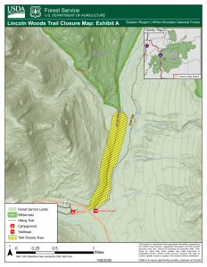
The Pemigewasset Loop (often called the Pemi Loop) is an iconic 31-mile loop in the Pemigewasset Wilderness, a 45,000-acre area in the center of the White Mountain National Forest. Whereas we call it a loop, it’s really lollipop-shaped with a short stick (1.4 miles – the end of the Lincoln Woods Trail) at the bottom/Southern end of the loop that serves as starting and ending chute that link the Osseo Trail to Highway 112. This summer, that “lollipop stick” will be closed from June to November for much-needed trail work on an eroding river bank resulting from flooding over the last decade.
During the summer season there will be heavy earth moving equipment along the closed trail, and this construction equipment and work is incompatible with public use of the trail for health and safety reasons. Any violation of this prohibition is punishable as a Class B misdemeanor by a fine of not more than $5,000 for individuals and $10,000 for organizations.
While the classic Pemi Loop starting and ending at Lincoln Woods won’t be possible in summer 2026, the majority of the loop is still accessible. Hikers will need to use alternate access points instead of the 1.4‑mile Lincoln Woods approach, and these alternatives will add mileage to the traditional route.
The closure of the Lincoln Woods Trails between Highway 112 and the junction of the Osseo Trail also impacts some other popular routes, including:
- Owl’s Head
- 13 Falls
- The Bonds (day trip or Zealand/Bonds Traverse)
- Guyot
- Camp 16 / Black Brook Trestle
Our partners at the Forest Service have asked us to share this news, and they are helping our community identify alternative routes that use open trails this summer.
Pemi Loop Alternatives in 2026
I worked with AMC’s staff team, including Alex DeLucia on the Trails Team, Chris Thayer on the Policy Team, Emily Davenport on the Guide Team, and Sarah Nelson on the Research Team to help you make alternate plans this summer. Here’s what they had to say:
If you want to do something close to the Pemi Loop, that is still possible—just with different access points. It’s important to note that all alternative routes are longer than the traditional 31‑mile loop, ranging from approximately 36 to 40 miles.
- Greenleaf Trail Access: Rather than the traditional Lincoln Woods approach, the Greenleaf Trail is 3.8 miles to access the Pemi Loop at Mount Lafayette. Hikers will start and finish at the Greenleaf Trail Parking at the Cannon Tram. Pemi Loop mileage would total 36 miles starting and ending at this trailhead.
- Skookumchuck Trail Access: For this approach, hikers will start at the Skookumchuck Trailhead and hike 4.3 miles before joining the Pemi Loop via the Garfield Ridge Trail, accessing the loop approximately one mile north of Mount Lafayette. Total mileage for the Pemi Loop starting at this trailhead is 37 miles.
- Garfield Trail Access: For this approach, hikers start and finish at the Garfield Trailhead on the Gale River Road, off Route 3. This route accesses the Pemi Loop near Mount Garfield and is a 4.8 mile approach. Total mileage with this access point for the Pemi Loop is 38 miles.
- Gale River Trail Access: This approach starts and ends at the Gale River Trailhead on Gale River Road, accessible from Route 3 and is also served by an AMC hiker shuttle. Gale River Trail is 4.2 miles to the intersection with the Pemi Loop via the Garfield Ridge Trail and joins the loop between Mount Garfield and South Twin Mountain. The total distance with this access point is 36.8 miles.
- North Twin Access: This route starts and ends at the North Twin Trailhead on Haystack Road off Route 3. This 5.6 mile approach accesses the Pemi Loop at the summit of South Twin Mountain. The total distance of the Pemi Loop with this access point is 39.6 miles.
Alternatives for Other Routes Impacted by Trail Closures in 2026
For the other routes impacted by the Lincoln Trail closure in 2026, here are some suggested alternatives:
Owl’s Head
- Gale River Trail to Garfield Ridge Trail to Twin Brook Trail to Lincoln Brook Trail to Owl’s Head Path
- 11.9 miles one way
- Suggest camping at 13 Falls Tentsite or staying at Galehead Hut to make this more doable (23.8 miles round trip is high mileage for the Whites/Wilderness Area)
13 Falls Tentsite
- Garfield Trail to Garfield Ridge Trail to Franconia Brook Trail
- 7.7 miles one way
- Passes Garfield Ridge Campsite along the way
- Gale River Trail to Garfield Ridge Trail to Twin Brook Trail
- 7.4 miles one way
- Passes Galehead Hut along the way
The Bonds (day trip or Zealand/Bonds Traverse)
- Zealand Trail to Twinway Trail to Bondcliff Trail
- 8 miles to West Bond, one way
- 9 miles to Mount Bond, one way
- 10.2 miles to Bondcliff, one way
- Could stay at Zealand Hut and/or Guyot Campsite
- North Twin Trail to Twinway Trail to Bondcliff Trail
- 8.9 miles to West Bond, one way
- 9.9 miles to Mount Bond, one way
- 11.1 miles to Bondcliff, one way
- Gale River Trail to Twinway Trail to Bondcliff Trail
- 8.9 miles to West Bond, one way
- 9.9 miles to Mount Bond, one way
- 11.1 miles to Bondcliff, one way
- Can stay at Galehead Hut or Guyout Campsite
Guyot
- Same 3 hike options as the Bondcliffs
- Zealand approach: 7.3 miles, one way
- North Twin approach: 8.2 miles, one way
- Gale River approach: 8.2 miles, one way
Camp 16 / Black Brook Trestle
- These areas are south of the Bonds, so an alternative would be the same options as the routes to the Bonds from the North
- Camp 16/ Black Brook Trestle is 4.4 miles south of Bondcliff
- Zealand approach: 14.6 miles one way
- North Twin approach: 15.5 miles one way
- Gale River approach: 15.5 miles one way
Some Final Thoughts
All these routes pass through designated Wilderness Areas, where management and maintenance standards differ from those in the broader National Forest. Trails may be less maintained and more difficult to follow.
When considering where to stay overnight during your Pemi Loop or nearby hike, here are some considerations:
- Campsites
- Liberty Springs Tentsite
- Garfield Ridge Campsite
- Guyot Campsite
- Huts
- Greenleaf Hut (1.1 miles off Pemi Loop)
- Galehead Hut
- Zealand Falls Hut (nearby and on the edge of the Pemi Wilderness but not technically on the loop)
Emily shared with me that it might also be worth acknowledging that some people might try to cross the East Branch of the Pemigewasset River from the Pemi East Trail to try and access these hikes. The Forest Service reminds us that: “All river crossings can be challenging, and river levels can fluctuate daily. Exercise extreme caution when crossing any river or stream. It is up to each person to assess the conditions on site when deciding when whether to cross.” This crossing takes knowledge and risk assessment skills; it is wide with strong currents at times.
Hiring an AMC Guide is always an option no matter which itinerary you choose for your adventures this summer.