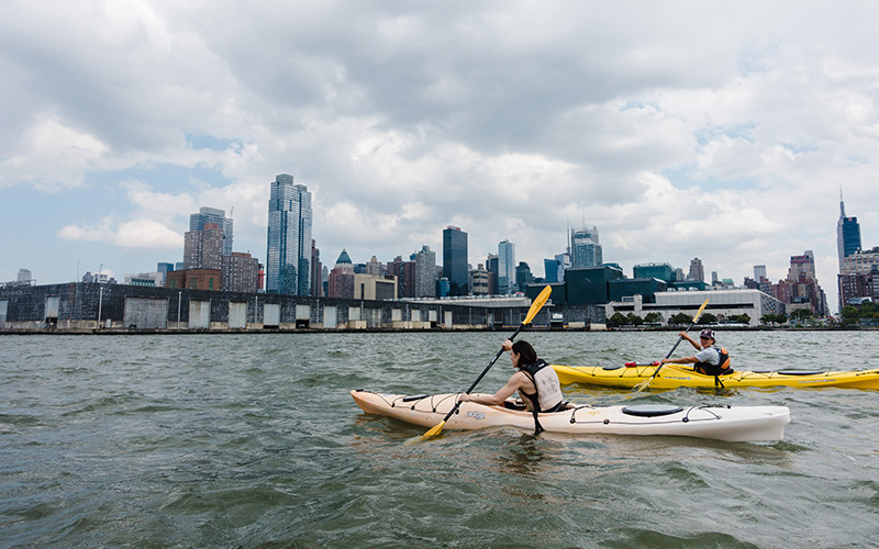

The Hudson River Water Trail begins in the Adirondack Mountains and leads all the way to Manhattan.
Water trails, like their land-based counterparts, lead us through diverse landscapes, challenge us with varying levels of difficulty, and provide a new vantage from which to see the world. For paddlers of all types, kayak or canoe, whitewater or flatwater, the Northeast and Mid-Atlantic offer a wealth of routes connecting navigable, publicly accessible bodies of water, creating options for day trips or multiday adventures. Here are eight of our favorites.
1. MAINE ISLAND TRAIL
Kittery to Eastport, Maine
This trail links a network of public and private land across 375 miles of coast, including more than 200 mainland and island sites. The trail terminates in Kittery, to the south, and near the U.S.–Canada border, to the north, passing through iconic Maine locations—Casco Bay, Acadia National Park—en route. With its rustic island campsites, often on private property, the Maine Island Trail relies heavily on a strong ethic of Leave No Trace, and the open-ocean route means paddlers will need to navigate tides and commercial boat traffic.
DISTANCE: 375 miles
INFO: Maine Island Trail; AMC’s Best Sea Kayaking in New England (AMC Books)
2. CONNECTICUT RIVER PADDLERS’ TRAIL
Pittsburg, N.H., to Old Lyme, Conn.
The Connecticut River, designated in 2012 as America’s first National Blueway, stretches from its headwaters in northern New Hampshire and Vermont south to Long Island Sound. Fifty-one primitive campsites dot the length of New England’s longest river, including two new sites, in Whately and Montague, Mass., that AMC built and opened in 2016. This trail passes through the heart of the Silvio O. Conte National Fish and Wildlife Refuge, which protects portions of the four-state river’s 7.2-million-acre watershed.
DISTANCE: 410 miles
INFO: Connecticut River Paddlers’ Trail; Connecticut River National Blueway; Quiet Water New Hampshire and Vermont, 3rd edition
3. NORTHERN FOREST CANOE TRAIL
Old Forge, N.Y., to Fort Kent, Maine
The Northern Forest Canoe Trail links 22 rivers and streams and 58 lakes and ponds from the Adirondacks in New York through Vermont, Quebec, and New Hampshire, all the way to Fort Kent at the northern tip of Maine. Designed in the 1990s, this recreational route was based, in part, on routes once paddled by American Indians and early settlers to the region. The trail now links 45 rural communities and provides paddling of all varieties, from flatwater to whitewater, with stretches on such famed waterways as the Saranac, Connecticut, and Ammonoosuc rivers.
DISTANCE: 740 miles
INFO: Quiet Waters New York, 3rd edition; Quiet Water Maine, 3rd ed. (AMC Books; coming soon); Quiet Water New Hampshire and Vermont, 3rd ed. (AMC Books)
4. SHETUCKET RIVER WATER TRAIL
Windham to Norwich, Conn.
Last Green Valley, which straddles the border of eastern Connecticut and southern Massachusetts, is home to three National Recreation Water Trails (a Department of Interior designation bestowed on waterways with special recreation value): the Quinebaug River, the Willimantic River, and the Shetucket River. All three eventually reach the Thames River, which flows into Long Island Sound in New London, Conn. The most recent addition to the Water Trails program, designated in 2016, the 20-mile Shetucket River Water Trail flows through dense forestland and past historic mill towns. Four dams divide its path from Windham’s Lauter Park to its terminus, in Norwich’s Brown Park.
DISTANCE: 20 miles
INFO: National Heritage Corridor, The Last Green Valley; American Trails
5. BRONX RIVER BLUEWAY
New York City
Flowing through the heart of the Bronx, on its way to the East River, is the Bronx River Blueway. A National Water Trail designee, the blueway begins at Shoelace Park to the north and flows around and under a mix of natural and developed sites, including some of the most heavily trafficked roads in the city, such as the Cross Bronx Expressway and Interstate 95. It also passes through the Bronx River Forest, the Bronx Botanical Garden, and the Bronx Zoo—right alongside the bison enclosure. The flatwater route has seven access points and three portages.
DISTANCE: 8 miles
INFO: Bronx River
6. HUDSON RIVER WATER TRAIL
Adirondack Park, N.Y., to New York City
The Hudson River Water Trail links the wilderness of upstate New York’s Adirondack Mountains to downtown Manhattan, featuring more than 100 access points and 15 campsites along its journey south through Albany, Poughkeepsie, and under the George Washington Bridge. The trail ends at the river’s head, at Battery Park on Manhattan’s southern tip. Check out the trail’s website for recommended itineraries, which range from themed one-day outings (lighthouses, wildlife, history) to multiday camping trips.
DISTANCE: 256 miles
INFO: Hudson River Greenway Water Trail; Hudson River Watertrail Association; Quiet Water New York, 2nd ed. (AMC Books)
7. DELAWARE RIVER WATER TRAIL
Hancock, N.Y., to Trenton, N.J.
The Delaware, the largest un-dammed river east of the Mississip- pi, covers 330 miles, from southern New York to the Delaware Bay, 200 miles of which have been designated the Delaware River Water Trail. A variety of flatwater, Class I, and Class II rapids offers a little something for paddlers of all levels, while a network of campsites allows for an extended journey. In addition to its recreational value, the Delaware River provides drinking water to 7 percent of the U.S. population, and its watershed is a focal area for AMC’s conservation work in the Mid-Atlantic.
DISTANCE: 200 miles
8. CAPTAIN JOHN SMITH CHESAPEAKE NATIONAL HISTORIC TRAIL
Chesapeake Bay (Delaware, Maryland, D.C., and Virginia)
This epic trail—the first water-based National Historic Trail—spans 3,000 miles in the Chesapeake Bay and its tributaries, tracing the routes sailed by the explorer John Smith between 1607 and 1609. A modern highlight, the trail’s so-called smart buoys collect and transmit weather and water data to researchers and boaters. Paddlers can access this geographical and historical information via smartphone.
DISTANCE: 3,000 miles
INFO: Smith Trail; AMC’s Best Sea Kayaking in the Mid-Atlantic (AMC Books)